

































































































































































































































































































































































































































































Super Typhoon Bavi: Powerful Category 5 Storm Leaves Trail of Destruction, Asia on Alert
Super Typhoon Bavi has emerged as one of the strongest tropical cyclones of 2026, battering Guam and the U.S. Northern Mariana Islands with destructive winds, torrential rainfall, and dangerous storm surges before continuing its journey across the Philippine Sea toward East Asia.
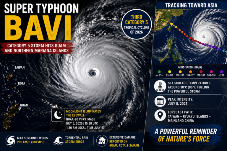
According to satellite observations released by NASA Earth Observatory, Bavi became the third Category 5 tropical cyclone of 2026, reaching maximum sustained winds of approximately 290 km/h (180 mph) at its peak.
NASA Captures Stunning Satellite Images
NASA Earth Observatory released dramatic nighttime satellite imagery captured by the VIIRS (Visible Infrared Imaging Radiometer Suite) aboard the NOAA-20 and NOAA-21 satellites.
The images show:
- A perfectly defined eye of the cyclone
- Moonlight illuminating the western eyewall
- Massive spiral cloud bands stretching across the Philippine Sea
- The storm moving westward toward Asia
The images were captured during the night of July 5, when Bavi was near peak intensity.
Bavi Crossed Guam and Northern Mariana Islands
The super typhoon passed across:
- Guam
- Rota
- Saipan
- Northern Mariana Islands
Residents experienced:
- Winds up to 290 km/h
- Torrential rainfall
- Dangerous storm surge
- Flash flooding
- Widespread power outages
- Fallen trees and power lines
- Damage to homes and public infrastructure
Reports indicate that a water distribution station on Rota also suffered damage.
Coast Guard Begins Recovery Operations
Following the storm, U.S. Coast Guard crews launched emergency operations to:
- Clear navigation channels
- Remove marine debris
- Restore port operations
- Assist local emergency agencies
Authorities continue damage assessments across affected islands.
Storm Continues Toward Asia
After crossing the Mariana Islands, Bavi continued west over the Philippine Sea.
Forecast models indicate the storm could move toward:
- Taiwan
- Ryukyu Islands (Japan)
- Eastern China
Although gradual weakening is expected, the cyclone is forecast to remain a dangerous typhoon for several days.
Why Did Bavi Become So Powerful?
Meteorologists say unusually warm ocean waters played a major role.
Key factors include:
- Sea surface temperatures around 30°C (86°F)
- Favorable atmospheric conditions
- Developing El Niño pattern
- Extended travel over warm ocean water
Experts note that El Niño years often allow typhoons to strengthen more rapidly before reaching Asia.
Key Highlights
| Feature | Details |
|---|---|
| Storm Name | Super Typhoon Bavi |
| Intensity | Category 5 |
| Peak Wind Speed | 290 km/h (180 mph) |
| Ocean | Philippine Sea |
| Affected Areas | Guam, Rota, Saipan, Northern Mariana Islands |
| Next Threat | Taiwan, Ryukyu Islands, China |
| Satellite | NOAA-20 & NOAA-21 VIIRS |
| Weather Driver | Warm seas and developing El Niño |
Areas Under Watch
Authorities are closely monitoring conditions in:
- Taiwan
- Southern Japan
- Ryukyu Islands
- Eastern China
- Coastal shipping routes across the Philippine Sea
Residents have been advised to follow official weather warnings and emergency instructions.
Why This Storm Matters
Bavi is another reminder of the increasing intensity of tropical cyclones in the Pacific. With multiple Category 5 storms already recorded this year, meteorologists are closely studying the influence of warmer oceans and the developing El Niño on storm formation and rapid intensification.